Types Of Marine Navigation Instruments, Tools And Equipment Used Onboard Ships
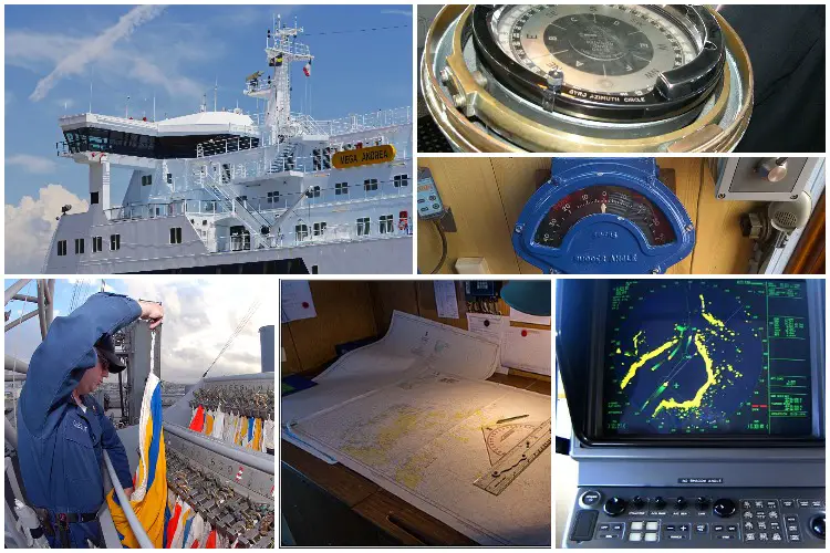
For centuries ships have been used for various purposes such as a means of transport, to carry cargo, and for battles, etc. Ships have been used for trade and travel since the earliest times.
Even today, ships have not lost their importance. Ships have several advantages over other means of transport such as road and air. Still, ships are not easy to use or maintain.
The oceans can be quite treacherous, and the passengers and crew of a ship need to be fully prepared in case of emergencies. Various types of modern navigation instruments, equipment, and tools are used in the current ships to help the captain and sailors in the vast and treacherous seas.,
List of Marine Navigation Instruments, Tools And Equipment Used Onboard Ships
There are thousands of equipment present onboard a modern-day ship. Several of these are relatively new and have made it easier for a pilot to navigate through the waters. Here is the list of different types of navigational equipment used onboard modern ships explained briefly.
1. ARPA
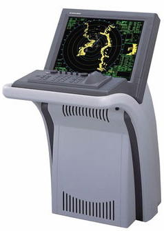
An ARPA or an Automatic Radar Plotting Aid is a system that is used for creating tracks with the use of radar contacts. This system can calculate the course, speed and the closest point of approach (CPA) of a tracked object. This helps to determine if the ship is in danger of colliding with another large object like an iceberg, another ship or a landmass.
ARPA allows the observers to obtain radar information reducing their work automatically. It enables the tracking of multiple targets with high accuracy and improves collision avoidance at sea.
The ARPA is directly connected with the radar from which it receives a continuous stream of data which is then processed and displayed graphically. All this is done by a computer which does the plotting and display of the vectors of the tracked targets.
Also read: What Is A Marine Sextant?
2. ATA
An ATA or an Automatic Tracking Aid is quite similar to an Automatic Radar Plotting Aid. This navigation instrument is also used for creating tracks with the use of radar contacts. It displays the information about the tracked objects in the form of numbers or graphics.
This helps in creating a planned layout to make the course collision-free. An ATA allows manual acquisition and automatic tracking of multiple targets entering an acquisition area.
3. Speed and Distance Log Device
Speed and distance log device is a piece of navigation equipment used for measuring the speed and distance that the ship travels from a particular reference point.
In this manner, it becomes easy to calculate the estimated time of arrival of the ship at a particular place and this time is conveyed to the port authority. It can also be used to adjust the ETA in case of any issue of traffic at the dock.
4. Pilot Card
A pilot card is a booklet of information provided to the pilot of the ship. It consists of information about the ship such as dimension, draught maneuvering, propulsion equipment, turning circle, etc.
The main purpose of it is the safe maneuvering of the vessel. A pilot card is the first thing that a Marine pilot looks for when he is on board the ship.
5. Echo Sounder
As the name suggests, an echo sounder is a device used for echo sounding. Echo sounding is a process which is used to measure the depth of water below a ship by the transmission of sound waves into the water.
The time interval between the emission of a sound wave and the return of the pulse is recorded. This, along with the speed of sound in the water at the given time is used to determine the depth of water at the given point.
6. Electronic chart display and information system
An Electronic Chart Display and Information System or an ECDIS is a geographic system of information. It is used for nautical navigation. This system complies with the IMO or the International Maritime Organization.
ECDIS makes it easy for the crew of a ship to pinpoint different locations and get directions more easily than using the conventional nautical charts.
7. Automatic identification system
An Automatic Identification System or AIS is a system that automatically tracks the location and other statistics of ships. All this information provided by the device can be displayed on the screen or an ECDIS.
An AIS transmit and receive messages between ships with the help of VHF radio channels.
8. Long range tracking and identification system
A Long-Range Tracking and Identification System abbreviated as LRTIS is an international system established by the International Maritime Organisation or the IMO that applies to all passenger ships, cargo ships, and mobile offshore drilling units.
This system was incorporated to ensure a thorough tracking system for ships all over the world. According to the system, the ships must report their positions to the respective flag administrations for a minimum of four times a day. In most vessels, the reports are made automatically using satellite communication.
9. Voyage Plan
As the name suggests, a voyage plan is a plan with which the ship would sail. Voyage planning is a procedure that completely describes the journey of a ship from beginning to end in detail. It includes leaving and harboring areas.
It is usually the second officer who is in charge of passage planning of the ship. Voyage planning is an important and tedious job as most of the navigational accidents are caused due to human error.
10. Rudder Angle Indicator
A Rudder Angle Indicator is a device which is used to determine the current position of the rudder blade. It provides the angle of the rudder, as the name suggests. It is installed in the control house of the bridge. The bridge provides a display to control the rate of the rudder angle of the ship.
11. Voyage data recorder
A Voyage Data Recorder or a VDR is a data recording system which is installed in the ship. It records the important events related to its operations. It also has an in-built voice recording. This device records the information for a period of at least the last 12 hours. This device is useful at times of accidents or misfunctioning of ships.
12. Rate of turn indicator
The Rate Of Turn Indicator or a ROTI indicates the rate at which a ship is turning in degrees per minute. In simple words, it shows how fast a ship is turning. It is the most important device that one could need while steering a course. This device is beneficial as it can be used for turning steadily or at a particular desired rate.
It is of two types that is digital and analog. The most commonly used is the analog type because it reads the rate of turn very fast.
13. Forecastle Bell
A Forecastle Bell is a kind of alarm that brings and provide a warning when there is fog or bad weather around the ship. It is used in case of an emergency. It is just a precautionary or warning device.
14. Maneuvering Booklet
Maneuvering booklet is a record of propulsion plan of a ship during maneuvering in different kinds of weather situations. This booklet is provided for quick reference for the pilot of the vessel. It helps the pilots get an idea of how to maneuver the ship depending upon the weather conditions and the history of the equipment of the ship.
15. Black Ball Shape
A black ball shape is a signaling shape. It is used during the daytime. It helps a pilot to determine the characteristics of a particular vessel with different arrangements of ball shapes.
These are used during the daytime because lights cannot be used. For instance, a vessel which is at anchor will show a black ball at the forward end of the forecastle. Similarly, a ship which is not under command will show to black balls in a vertical line on the main mast.
16. Record of navigational activities
It is mandatory for ships to record all the navigational activities taking place on board. The most important part of this is the log book. A log book is a record of any kind of event or events taking place on the ship during a voyage.
A log book is usually maintained by the captain or the main pilot of the ship. Every ship in the world has a log book which needs to be updated regularly.
17. Record of maintenance of navigational equipment
Record of maintenance of navigational equipment is a hard copy of did navigational equipment on board the ship. It should be readily available on the vessel for quick references. It also needs to be duly signed by the master and all the duty officers of the ship.
18. Wheelhouse Posters
A wheelhouse poster is a poster that displays all the information about the maneuvering characteristics of the ship in great detail. It is present in the navigation bridge. Every ship nice to have a wheelhouse poster.
19. Transmitting heading device
A transmission heading device is a navigation instrument used to display the details about the true heading of any ship.
20. Black diamond shape
A black diamond shape is a signal used during the day. Day shapes are signals switch to indicate the status of the vessel to the vessels nearby. A black diamond shape is a signal which is used to indicate that a ship is being towed. It is employed when a ship is unable to maneuver by itself. It helps the other nearby vessels to understand the current situation of a vessel at daytime.
21. Ship Flags
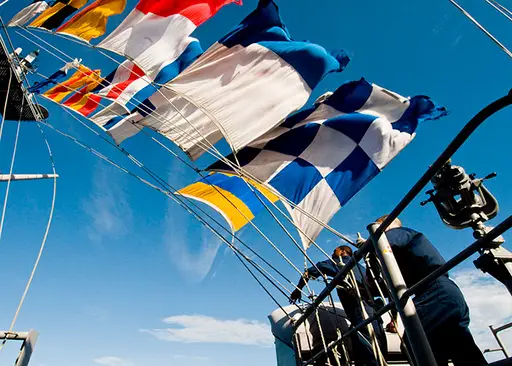
Ship flags are signals with different colors and signs on them indicating the position of the ship. They are also called signal flags. Signal flags have been in use for centuries.
22. Gyro Compass
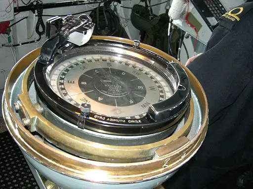
A Gyro Compass is a kind of compass used at the time of a sea voyage. Unlike ordinary compasses, a gyromagnetic compass does not get affected by an external magnetic field. It automatically finds a geographical direction based on the rotation of the earth.
These compasses have two main advantages over magnetic compasses. Firstly, they find the true north which is more useful than the magnetic north for navigation. Secondly, they are not affected by other ferromagnetic material like the parts of the ship.
23. Radar
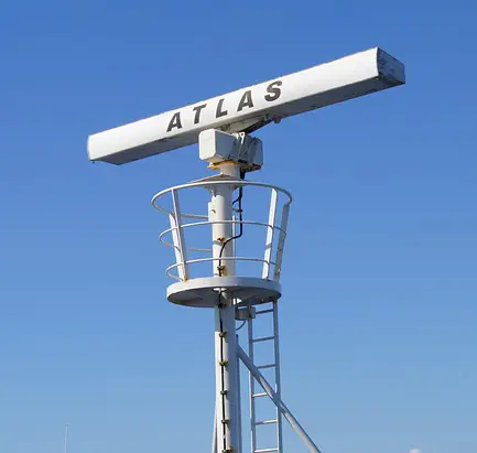
A marine radar or simply, radar is a device used to detect or measure the distance between the ship and other floating devices like other ships or even land. Radars are electronic instruments. They use a rotating antenna which sends microwave signals around the surface of the water around the ship. The reflection of microwaves helps to detect the presence of another body in the proximity to the ship.
24. Magnetic Compass
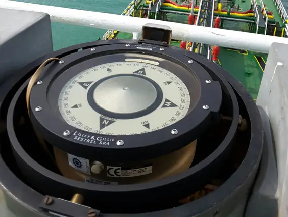
A magnetic compass is a navigation device used to find the northern direction with the help of the earth’s magnetic field. Magnetic compasses are the most commonly used type of compasses. The compass has a diagram on it that has the four direction that is North, East, West, and South marked on it. The compass has a rotating needle which points towards the north. The magnetic compass is one of the four great inventions.
25. Auto Pilot
An autopilot is a system that is used to keep a vessel on a set course without any person needing to intervene. It is an electronic or hydraulic system. An autopilot can relieve the crew of a ship from the task of steering the ship manually.
It should be noted that an autopilot cannot completely replace a human being. It can, however, assist in controlling the ship while human resources can be used for other operations like monitoring the weather or trajectory.
26. GPS Receiver
A GPS receiver or a Global Positioning System receiver is a system which is used to display the location of the ship by using Global Positioning Satellites in the earth’s orbit.
The device is used to display the position of the ship on a map and offer directions as well. GPS is a very common system nowadays. It is also installed on our mobile phones, and it helps us find directions all over the world.
Earlier, LORAN (Long Range Navigation) system were used. LORAN was GPS precursor for ships and planes.
27. Sound Reception System
A sound reception system is a navigational aid that enables an officer to hear a sound signal coming from outside of a completely enclosed bridge. The sound signals could be foghorns from other ships.
Installing Sound reception system in every ship is mandatory. They are also sometimes installed in ships which do not have completely closed bridges.
28. Navigation Lights
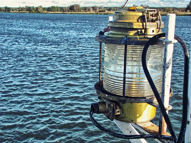
Navigation lights or night lights are sources of illumination on any vessel or aircraft. They provide a good idea about a ship’s position and status. Every ship whether small or large needs to have night lights as it is a crucial part of the navigation system.
United States first introduced navigational light bulbs in 1838. The United Kingdom later adopted them in 1849. They were officially adopted internationallyby 1897.
29. Ship whistle
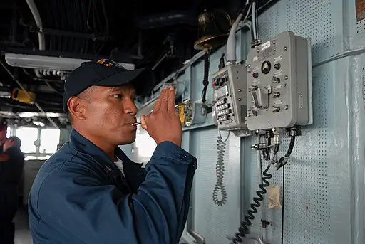
The horn of the ship is known as a ship whistle. It is mandatory according to the International regulations to have a whistle onboard in all the seafaring vessels. The whistle should always be in good working condition and audible.
A whistle can provide prolonged blast at appropriate time intervals. Whistles usually can be both manually or electrically operated. The whistle switches are mostly located on the bridge wings or inside the bridge.
30. Daylight Signalling Lamp
A Daylight Signalling Lamp is a device used for lights signaling at the time of emergencies during the time of the day. They were first used in the Royal Navy in the late 19th century. They are deployed for safe and secure communications during the period of radio silence. As a secondary function, they are also act as spotlights.
31. Chart Table
A chart table is a horizontal surface big enough to accommodate a chart. The table can either have a lifting top with storage space underneath or a drawer. A chart table should be kept in a place with most stability which is usually the companionway with the seat facing the front.
32. Parallel Rulers
Parallel rulers are a drafting instrument used by navigators to draw parallel lines on charts to plot direction. The tool consists of two straight rulers joined by two arms which allow them to move close or apart from each other but remain parallel at all times.
33. Logbook
A logbook is used to record position, distance run and other data. It is compulsory to keep and maintain a log book.
34. Marine Binoculars
The standard size of marine binoculars is 7 x 50. It means that it has 7 times magnification and the objective lenses are 50mm in diameter. Any more magnification with a steady view gets progressively harder beyond this.
35. Depth Sounder
Depth sounder sounds an alarm and also indicates depth when a particular depth is achieved.


![The Unsolved Mystery Of Devil’s Sea [Dragon's Triangle] 16 The Unsolved Mystery Of Devil’s Sea [Dragon’s Triangle]](https://www.maritimemanual.com/wp-content/uploads/2019/03/devils-sea-dragons-triangle.jpg)

Thank you for the valuable information.A must read for every seafarers.