15 Interesting Facts About The Straits of Gibraltar
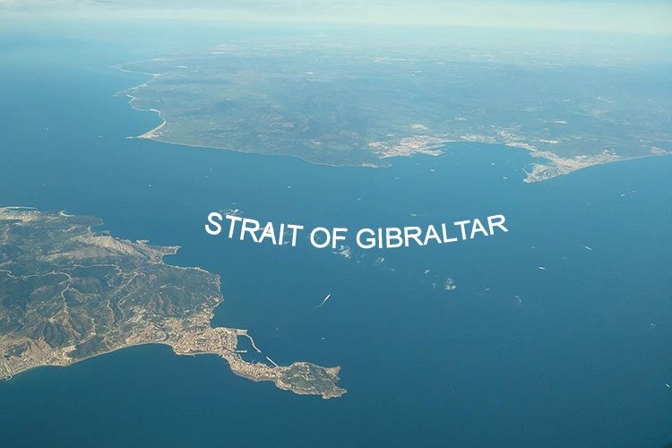
Here are some of the fascinating stories and facts about the Straits of Gibraltar which is one of the world’s busiest shipping routes and as such has been of great geopolitical importance.
Located at the southern tip of the Iberian peninsula, Gibraltar is a British overseas territory. The strait witnesses a lot of illegal migration from the African continent to Europe due to its location. The landscape is mostly covered by The Rock of Gibraltar near which the strait flows known as The Strait of Gibraltar.
Gibraltar is also known as the “key to the Mediterranean”
This strait played a significant role in World War I as it became the doorway to the Mediterranean Sea. The strait is a link between The Atlantic Ocean to the Mediterranean sea. It has a long history and diverse culture. The strait has been strategically significant and hence many countries have disputes related to the rights over the strait. Military usages have increased in recent years as Spanish and Moroccan armed forces conduct joint exercises from time to time in the strait.
The strait is about 13km wide and its average depth is 450 meters. The maximum depth of the strait is 900 meters. The narrowest point of the strait lies between Spain’s Point Marroqui and Morocco’s Point Cirrus. These are the physical features of the strait.
Along with historical aspects, there are a lot more things to look out for like the tourist spots, the food, biodiversity, etc. in the Strait of Gibraltar. It is one of the busiest straits as now and then, small boats or ferries travel through it.
15 Interesting Facts About The Straits of Gibraltar
There are some interesting facts about The Strait of Gibraltar and so let’s get started with it.
1. Gibraltar is a British overseas territory
Gibraltar is a British overseas territory despite Spain and Morocco being closest to it. When we look at the maps, at the top of the strait is Spain and at the bottom is Morocco. These countries are the closest to the strait yet it comes under the British overseas territory.
During the War of the Spanish Succession, Anglo-Dutch forces took control over Gibraltar from Spain. It was then handed over to Great Britain in 1713, under the name of the Treaty of Utrecht for ensuring the long-lasting bond with Great Britain. This was opposed by Spain for many centuries.
Gibraltar is represented by the United Kingdom and therefore is not a member of the Commonwealth of Nations. Furthermore, in 2004 it was given the associate membership of the Commonwealth Foundation. Gibraltar has been actively participating in Commonwealth games since 1958.
2. Biodiversity
The strait has the Mediterranean sea on one side and the Atlantic ocean on the other side which makes it an important area for birds, specifically for migratory birds. Thousands of birds come here during the migration period. So birdlife is a factor to look out for. The bird species found here are Scopoli’s shearwater, Balearic shearwater, Audouin’s gull, lesser black-bucked gulls, Atlantic puffins, and razorbills.
Also, the strait is home to killer whale pods, very few of them are left in western European waters and are getting extinct due to long-term PCB (Polychlorinated Biphenyls) pollution.
3. Origin of the name
The name of the strait comes from The Rock of Gibraltar which originates from the Arabic name ‘Jabal Tariq’ meaning Tariq’s mountain. In Arabic ‘Jabal’ means mountain and Tariq was a commander who crossed the strait from the Northern Africa coast along with his troops and hence The Rock of Gibraltar is named after him.
It is sometimes also called Gut of Gibraltar, although that is very old. In Arabic, it is called Bab-al-Maghrib which means, “Gate of Morocco” or “Gate to the west”. Muslims called it Az-Zuqaq, which means “the passage”, during the middle ages. In Roman it is Fretum Gaditanam, meaning Strait of Cadiz and anciently it was called Pillar of Hercules.
For Naval purposes it is shortened to STROG, that is STR of “Strait”, O of “Of” and G of “Gibraltar”.
4. Language
Since it is British territory the official language is English. It is used in the government and schools. The region uses the Gibraltarian accent of English. It has been greatly influenced by the Muslim community because of the spread of Islam in North Africa and hence there are Arabic language speakers as well. As it is near Spain, Spanish is also spoken by many people along with English.
The region has a long history and therefore several ethnic groups resided near the strait of Gibraltar and the languages spoken by them wear Moroccon Arabic, Hindi, and Moroccan Berber. Llanito is a unique language of Gibraltar. It is a combination of Andalusian Spanish and British English. Maltese, Ligurian, Haketia, Genoese and Portuguese languages are also mixed into Llanito.
Berber and Maghrebi languages are also used by Moroccon people as the strait is in the vicinity of Morocco. Indian communities living near the areas of the strait speak Hindi or Sindhi and the Jewish community speaks Hebrew.
5. Trade and communication
It separates two continents i.e Europe and Africa. It is also a passage to the Mediterranean Sea. Therefore it has become a major trade route for many traders across different countries and continents.
It is the busiest shipping lane in the world after the English Channel. One-third of the world’s oil and gas transportation takes place through this strait. 80% of goods and gas required by the European Union has to pass through the strait of Gibraltar.
Spain and Morocco mutually agreed to the decision of constructing an undersea rail tunnel, in December 2003. This will strengthen the rail systems across the strait. The project is yet to be implemented. Recently, in 2012 officials from both countries met for the discussion of the project and it is predicted to be completed by 2025.
The waters of the strait are getting polluted because of the heavy trade traffic crossing daily through the strait and due to the spillage of oil or other materials from the ships. These issues have been addressed to IMO (International Maritime Organization) several times. Preventive measures have also been taken to tackle these issues. In 2003 Spain announced that tankers carrying heavy fuel oil, coal tar, or crude oil will be restricted from entering Spanish ports or terminals.
Also read: Bosphorus Straits: 10 Mind-Blowing Facts
6. One of the most crowded straits in the world
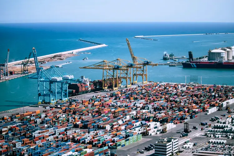
The strait is one of the most crowded straits in the world because many international cargo ship containers can easily pass through this strait and as a valuable trade route it has to be one of the busiest straits. The ships traveling from east to west were 65,000 and the ships traveling from north to south of the strait were 30,000 in the year 2006.
As mentioned above, it is a vital route through which about 110,000 vessels traveled from Southeast Asia, China, and the Middle East to Africa, the US, and the Atlantic coastline of Europe in 2014. Most of the oil and gas transshipment happens through the strait.
Over 100,000 ships cross the strait of Gibraltar every year and about 300 ships daily. Before the Suez Canal was built, the Gibraltar strait was the only oceanic access to travel in and out of the Mediterranean Sea. Some of the important ports along the strait are Port of Algeciras, Port of Tangier, and the port of Gibraltar. Spain and Morocco are planning to have more ports and hence these ports are increasing their terminals, thus giving rise to port capacity.
Spain’s most of the oil transportation is done via the Strait of Gibraltar. The strait is serving as the main route for tanker traffic carrying oil for European countries.
7. History and Evidence of human habitation
It is believed that Neanderthals may have resided at the Rock of Gibraltar and it may be the last place where their settlement can be seen as was found in the archaeological surveys. Evidence of their habitation was way back 125,000 years.
Homo Sapien’s habitation evidence is also found and it suggests that their habitation was way back to 40,000 years. Many civilizations are discovered here, as it is a short distance between two shores. Civilization in the 5th century witnessed Carthaginians going against the Romans and Vandals traveling to North Africa. In the 8-11th century civilizations by Moors and Berbers were seen in 16th century Spain and Portugal.
For the last 500 years, the strait has witnessed cultural differences on the Northern and southern sides of the strait. In the north, the Spanish forcibly removed the last Muslim government, and hence in the north, Christian-European culture is dominant and in the south Muslim or Arabic culture is dominant.
In 1704, established the small British territory in the strait, the city of Gibraltar. They did this to ensure the control of sea lanes for transportation through the Mediterranean sea.
8. Its boundaries are known as the ‘Pillar of Hercules’
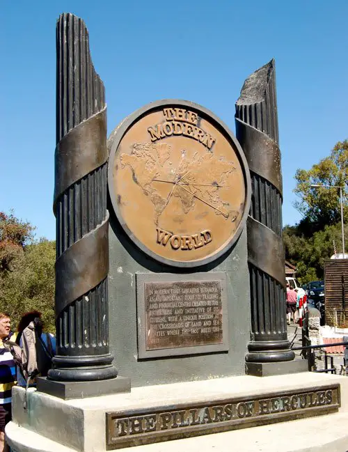
The Rock of Gibraltar is one pillar known as Caple Mons at the North and the other pillar at the south known as Abila Mons, together they form Pillar of Hercules.
According to Roman sources, Hercules had to cross through the mountain Atlas but instead of climbing the mountain, he smashed through it with his superhuman powers which connected the Atlantic ocean and the Mediterranean sea forming The strait of Gibraltar. The mountain is then split into two parts and the one part is Gibraltar and the other mountain is one among the Jebel Musa or Monte Hacho. These two mountains are then called the Pillar of Hercules.
An ancient Greek historian, Diodorus Siculus said that Hercules smashed through an already existing strait and he narrowed down the strait. He did this so that Atlantic Ocean monsters don’t enter the Mediterranean Sea.
Some sources say Hercules built the two mountains and created the Pillar of Hercules to hold the sky away from the earth so that he can liberate Atlas from eternal punishment in hell.
9. Territorial waters
The strait comes under the territorial waters of Spain and Morocco. Although Gibraltar is a British territory, it covers 3 nautical miles on the northern side of the strait claiming it to be under British territorial waters. According to British claims, remaining in the international waters.
Spain has disputes over the right on territorial waters of the strait. Similarly, Morocco has disputes with Spain for claiming rights over Ceuta, which is located on the north coast of Africa. The vessels and aircraft have the right to cross through the strait under the law of the United Nations Convention on the law of the sea.
Also read: Strait of Magellan: 10 Interesting Facts
10. Power generation by tides of the strait
The tidal energy from the strait water can be used for generating electricity. A lot of projects are proposed for this idea of power generation. The idea is to generate power by erecting tidal power generation stations within the strait.
A project called Atlantropa was proposed in the 1920s and 1930s for constructing a dam along the strait to generate a large amount of electricity and to lower the Mediterranean sea’s water level. This project would have reduced the sea level of the Mediterranean sea and created a huge amount of area for human settlement.
These proposals are not implemented yet because they will have an adverse effect on the climate and ecology. It can also change the physical features of the Monsoon of Western Africa.
11. The Europa Point
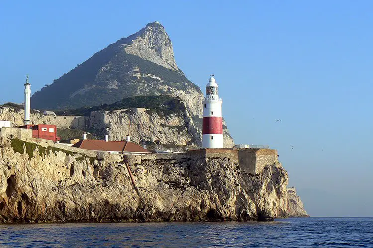
Europa Point is the southernmost point of Gibraltar. It is the point where both the Atlantic Ocean and the Mediterranean sea meet. The area is flat with playgrounds and some buildings near the end of Rock of Gibraltar. It is even possible to get views of North Africa across the Strait of Gibraltar on a clear day.
It has some beautiful features like the lighthouse, a mosque (Mosque of The Custodian of the Holy Mosques), an underground water shore, a Christian chapel (Nuestra Señora de Europa or the Shrine of our Lady of Europe), fortifications, and cannons. It is a famous tourist spot.
The notable buildings at Europa point are Harding Battery, the Roman Catholic Shrine of Our Lady of Europe, the Nun’s well, the Ibrahim-al-Ibrahim Mosque, and the Europa point lighthouse. Gibraltar national cricket team plays cricket at the Europa point as it has also a cricket ground.
12. Gibraltarian Cuisine

Just like the language variety, the food here is also diverse. The cuisine belonging to Gibraltar is a combination of Mediterranean and British cuisines. This beautiful combination gave rise to some of the exquisite dishes. The national dish of Gibraltar is Calentita which is an oven-baked meal nearly like a dark floured pizza without toppings.
We can find famous English dishes like Fish and Chips and also African dishes of Tapas and kebabs.
13. Connection of the Meditteranean-Atlantic
Due to the Zanclean flood, the connection between the Meditteranean sea and the Atlantic ocean was established by the Strait of Gibraltar. This happened 5.33 million years ago and since then the way has remained open and the connection between these water bodies has continued.
It is expected that the strait might close because of the African Plate movement towards the north compared to the Eurasian Plate.
14. Geology of the Strait
The geological aspects of the strait are of what sediment it is composed of and about the mineral concentrations beneath the strait.
The strait’s seabed is composed of Synorogenic Betic-Rif clayey flysch. The surface beneath the strait consists of bedrock surfaces, dunes, and coarse sediments. These formations took place due to the strong water currents at the bottom.
When the Mediterranean sea and the Atlantic ocean’s connection got restricted, the salinity of the water increased in the form of Gypsum and salt deposition range. This crisis was called the Messinian salinity crisis.
Due to various chemical and natural phenomena salt and mineral deposits are seen in the seabed of the strait. The dissolved mineral concentrations, the environment of the chemistry of water, temperature, and water currents of this waterbody combined and occurred many times. This gave rise to the precipitation of mineral salts on the seabed of the strait. Geological experts say that this happened in a short period, which is around 500,000 to 600,000 years.
15. Tourism in the Strait of Gibraltar
Tourism near the strait is famous. Gibraltar has many tourist spots and the areas around the strait serve as tourist spots.
The Europa point is a famous tourist attraction as it has many notable buildings and a beautiful location to enjoy the scenic beauty. It also has the Sikorski Memorial which was built in memory of the Polish army’s commander in chief who died due to an airplane crash.
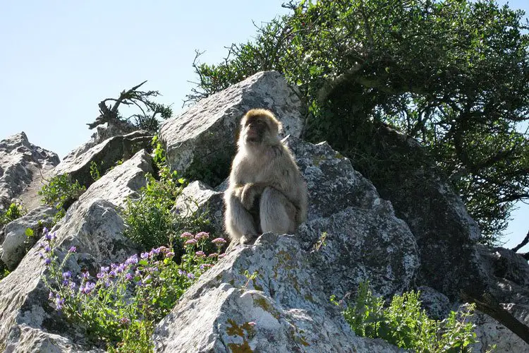
The famous Barbary Macaques, a species of monkeys can also be seen in Gibraltar. They are native to Morocco. You can see them in the Apes’ Den in Gibraltar Nature Reserve. This reserve is a great place to explore the natural wildlife and birdlife beauty of the area. Migratory birds stopover in this reserve during their travel between Africa and Europe. Gibraltar Nature Reserve also has other attractions such as St. Michael’s Cave and Forbes’ Quarry where one of the world’s first female Neanderthal skulls was found in 1848.
People can experience Dolphin watching through the viewing vessel that is built for marine wildlife adventures. We can watch these Dolphins swim through the strait.
Beaches near the strait are famous spots to be visited by tourists. With subtropical climates, beaches are a perfect place to visit.
Many other tourism activities like exploring Gibraltar Botanic gardens, museums, etc. can be enjoyed here in Gibraltar and places around the strait of Gibraltar.
These are some of the captivating facts about The Strait of Gibraltar. As we saw above, it has a fascinating history and greek mythological touch to it. It is an important Strait as it is a global shipping route.
Images courtesy:
1. https://www.flickr.com/photos/rabinal/7831705516/
2. https://commons.wikimedia.org/wiki/File:Berberaffen_Gibraltar_08.jpg


